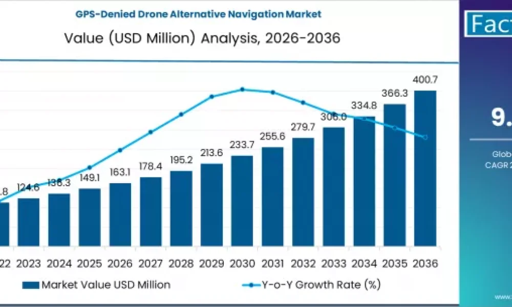
The global GPS-Denied Drone Alternative Navigation Market is projected to record strong growth over the next decade as commercial, industrial, and defense sectors seek reliable navigation solutions that operate effectively in environments where Global Positioning System (GPS) signals are weak, denied, jammed, or spoofed. Alternative navigation technologies enable drones to maintain accurate positioning, orientation, and routing when GPS is unavailable or compromised, ensuring mission continuity for critical applications such as inspection, surveying, security, delivery, and tactical operations.
Alternative navigation systems for GPS-denied environments integrate multiple sensing modalities—including inertial measurement units (IMUs), visual and LiDAR odometry, ultra-wideband (UWB) positioning, radar, magnetic sensing, and artificial intelligence (AI)-assisted sensor fusion—to support robust situational awareness and precision navigation. As drone use expands into complex indoor, subterranean, urban canyon, and electronically contested airspaces, demand for dependable GPS-independent navigation tools is becoming increasingly strategic.
Market Outlook (2026–2036)
Estimated Market Value in 2026: USD 0.82 Billion
Projected Market Value in 2036: USD 3.95 Billion
Forecast CAGR (2026–2036): ~16.8%
Leading Technology Segment: Sensor Fusion and AI-Assisted Navigation
Dominant End Use: Defense and Public Safety
Key Growth Regions: North America, Europe, Asia Pacific
The anticipated robust compound annual growth rate reflects expanding applications of autonomous systems in challenging environments and heightened requirements for navigation resilience.
To Access the Complete Data Tables & in-depth Insights, Request a Discount on this report: https://www.factmr.com/connectus/sample?flag=S&rep_id=13357
Market Overview
GPS signals may be unavailable or unreliable in environments such as dense urban areas, indoors, under bridges or tunnels, dense foliage, or when intentionally interfered with by adversaries. Traditional GPS-dependent navigation systems struggle in these contexts, leading to mission failures, data loss, or safety hazards. Alternative navigation technologies combine multiple onboard sensors, environmental perception tools, and advanced computing algorithms to estimate position and motion continuously without reliance on satellite signals.
Inertial measurement units provide high-frequency motion data, while visual odometry uses camera imagery to track feature movement relative to surroundings. LiDAR scans produce 3D maps for localization, and ultra-wideband radio can enable short-range positioning with fixed beacons in controlled environments. When integrated using AI-based sensor fusion, these technologies deliver accurate and robust navigation even where GPS is degraded or denied.
Key Market Drivers
1. Increasing Adoption of Autonomous Systems in GPS-Challenged Environments
Industries such as mining, warehousing, logistics, and infrastructure inspection deploy drones in areas where GPS access is limited or obstructed. Reliable navigation is critical in these use cases to ensure safety and mission success.
2. Heightened Defense and Security Requirements
Military and public safety agencies prioritize navigation resilience in contested or GPS-denied scenarios. Alternative navigation systems enhance operational effectiveness for reconnaissance, search and rescue, perimeter surveillance, and other tactical missions.
3. Advancements in Sensor Fusion and AI Algorithms
Progress in AI, machine vision, and multi-sensor fusion techniques improves navigation accuracy, SLAM (simultaneous localization and mapping) capabilities, and adaptive response in dynamic and complex environments.
4. Urban Air Mobility and Regulatory Push for Safety
As urban drone delivery and air mobility initiatives advance, navigation systems that maintain reliability in cluttered city landscapes are essential to regulatory approval and public acceptance.
Market Segmentation Insights
By Technology Type:
Inertial Navigation Systems (INS)
Visual and LiDAR Odometry Solutions
Ultra-Wideband (UWB) Positioning
Magnetic and Radar-Based Navigation
AI-Assisted Sensor Fusion Platforms
By Application Area:
Defense and Tactical Operations
Industrial Inspection and Monitoring
Logistics and Autonomous Delivery
Infrastructure and Construction Surveying
Emergency Response and Public Safety
By End User:
Defense Forces and Security Agencies
Commercial Drone Operators
Industrial Enterprises
Research and Academic Institutions
Service and Maintenance Providers
Regional Demand Dynamics
North America is expected to lead the market due to strong defense spending, widespread adoption of unmanned systems, and robust research investment in autonomous navigation technologies. Government agencies and private innovators alike are driving deployment of GPS-independent drone navigation across diverse applications.
Europe is another key region with active regulatory frameworks supporting autonomous systems in industrial and urban settings. Collaborative innovation between industry and academia is strengthening navigation alternatives for GPS-challenged operations.
Asia Pacific is projected to exhibit rapid growth as urbanization accelerates, manufacturing and logistics sectors expand, and governments invest in smart city and automated infrastructure inspection programs.
Emerging markets in Latin America and Middle East & Africa are beginning to adopt advanced unmanned systems and alternative navigation technologies as part of broader modernization efforts in defense and industrial automation.
Competitive Landscape
The GPS-Denied Drone Alternative Navigation Market is moderately competitive, encompassing aerospace and defense technology firms, sensor manufacturers, robotics innovators, and software developers specializing in autonomous navigation. Key competitive strategies include integration of high-precision sensor suites, development of AI-driven algorithmic frameworks, and partnerships with drone OEMs to deliver turnkey navigation solutions.
Vendors emphasize modular platforms that can be retrofitted to existing drone fleets as well as fully integrated navigation stacks optimized for specific mission profiles. Performance, robustness in diverse environments, ease of integration, and scalability are important differentiators in this market.
Future Outlook
The GPS-Denied Drone Alternative Navigation Market is expected to sustain strong momentum through 2036 as reliance on autonomous unmanned systems grows and the need for resilient navigation in GPS-limited environments becomes more critical. Continued advancements in sensor technologies, machine perception, and AI-based navigation will expand the capabilities and applications of drones across civilian and defense sectors.
As industries embrace autonomy and regulatory frameworks evolve to accommodate advanced navigation systems, alternative navigation solutions will remain essential components of future drone ecosystems, enabling safer, more reliable operations in complex and contested environments worldwide.
Have specific requirements or need assistance on report pricing or have a limited budget? Please contact [email protected]
About Fact.MR:
Fact.MR is a global market research and consulting firm, trusted by Fortune 500 companies and emerging businesses for reliable insights and strategic intelligence. With a presence across the U.S., UK, India, and Dubai, we deliver data-driven research and tailored consulting solutions across 30+ industries and 1,000+ markets. Backed by deep expertise and advanced analytics, Fact.MR helps organizations uncover opportunities, reduce risks, and make informed decisions for sustainable growth