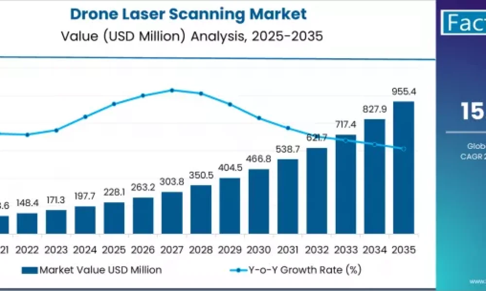
The global drone laser scanning market is set for exponential growth over the next decade, with valuations projected to rise from USD 228.1 million in 2025 to USD 955.4 million by 2035, according to a new report by Fact.MR. This surge represents an absolute market increase of USD 727.3 million, translating to a total growth of 318.8% and a robust CAGR of 15.4% between 2025 and 2035.
This growth trajectory reflects the increasing integration of LiDAR (Light Detection and Ranging) technologies with drones for high-precision mapping, 3D modeling, and digital infrastructure monitoring. The market’s momentum is further accelerated by its adoption across construction, forestry, agriculture, environmental monitoring, mining, and defense sectors.
Strong Regional Momentum Across North America, Europe, and APAC
North America and Europe remain at the forefront of drone laser scanning adoption, while Asia-Pacific (APAC) is rapidly emerging as a global hub for technological innovation and manufacturing integration.
The United States leads the market with a CAGR of 21.0%, driven by the deployment of drone-based LiDAR systems in infrastructure inspection, precision agriculture, and defense surveillance. European nations like Germany, France, and the UK are emphasizing digital twin technologies and smart city development, spurring demand for aerial 3D mapping.
In Asia-Pacific, countries such as Japan and South Korea are investing heavily in advanced sensing technologies and integrating drone laser scanning into transport infrastructure and environmental management systems.
To access the complete data tables and in-depth insights, request a sample report here:
https://www.factmr.com/connectus/sample?flag=S&rep_id=8150
Drone Laser Scanning Market Quick Stats
| Metric | Details |
| Market Value (2025) | USD 228.1 million |
| Forecast Value (2035) | USD 955.4 million |
| Forecast CAGR (2025–2035) | 15.4% |
| Leading Application | Topographic Mapping & 3D Modeling |
| Key Growth Regions | North America, Europe, Asia-Pacific |
| Key Players | RIEGL, Leica Geosystems, Trimble, DJI, FARO Technologies |
Driving Forces Behind Market Expansion
- Infrastructure Digitization:
Governments and private sectors are increasingly adopting drone laser scanning to create digital twins of roads, bridges, and buildings, ensuring improved safety, maintenance, and project planning. - Technological Advancements:
Integration of AI, real-time data analytics, and high-resolution LiDAR sensors enhances accuracy, reduces manual surveying costs, and accelerates data delivery for multiple industries. - Environmental and Forestry Applications:
Drone-based LiDAR solutions are widely used for forest canopy measurement, flood risk mapping, and terrain modeling, supporting climate monitoring and sustainable land management. - Cost Efficiency and Safety:
Drone laser scanning significantly reduces human risk in hazardous terrains and cuts down operational time and costs associated with traditional ground surveying. - Expansion in Mining and Agriculture:
From open-pit mining assessments to precision crop analysis, the technology is increasingly being adopted to optimize productivity and resource utilization.
Segment Overview
By Application:
- Topographic Mapping and Surveying
- Infrastructure and Construction Monitoring
- Forestry and Environmental Assessment
- Mining and Agriculture Inspection
- Defense and Security
By Component:
- LiDAR Sensors
- UAV Platforms
- GNSS and IMU Systems
- Data Processing Software
By End User:
- Construction and Civil Engineering
- Environmental Agencies
- Energy and Utilities
- Defense and Security Organizations
Competitive Landscape
Leading companies in the drone laser scanning market are leveraging innovation, strategic collaborations, and AI-integrated data solutions to strengthen their global market presence.
Key Players Include:
- RIEGL Laser Measurement Systems GmbH
- Leica Geosystems AG (part of Hexagon AB)
- Trimble Inc.
- Topcon Corporation
- DJI Innovations
- FARO Technologies, Inc.
- Teledyne Optech
- Hexagon AB
- Velodyne Lidar, Inc.
- Quantum-Systems GmbH
- GeoSLAM Ltd.
These players are investing in R&D, sensor miniaturization, AI-driven data processing, and multi-sensor drone integration to offer end-to-end solutions for precision surveying and mapping.
Regional Market Outlook
- North America: Driven by infrastructure modernization and defense applications in the U.S. and Canada.
- Europe: Strong growth in smart city projects, digital twins, and 3D asset mapping.
- Asia-Pacific: Emerging as a manufacturing and innovation hub with growing applications in construction and environmental management.
- Latin America: Increasing use of drone LiDAR for agriculture and resource mapping.
Purchase Full Report for Detailed Insights
For access to full forecasts, regional breakouts, company share analysis, and emerging trend assessments, you can purchase the complete report here: https://www.factmr.com/checkout/8150
Market Outlook: Shaping the Future of Digital Surveying
The global drone laser scanning market is entering a phase of technological acceleration and commercial maturity, transforming how industries capture, process, and visualize spatial data.
As industries move toward automation, precision mapping, and sustainable development, drone-based LiDAR systems will remain integral to next-generation geospatial solutions.
“Drone laser scanning is revolutionizing modern surveying by merging automation, accuracy, and efficiency,” said a Fact.MR research analyst. “With infrastructure digitalization and AI integration on the rise, this market is poised to grow fourfold by 2035.”
Have a specific Requirements and Need Assistant on Report Pricing or Limited Budget please contact us – [email protected]
About Fact.MR
Fact.MR is a global market research and consulting firm, trusted by Fortune 500 companies and emerging businesses for reliable insights and strategic intelligence. With a presence across the U.S., UK, India, and Dubai, we deliver data-driven research and tailored consulting solutions across 30+ industries and 1,000+ markets. Backed by deep expertise and advanced analytics, Fact.MR helps organizations uncover opportunities, reduce risks, and make informed decisions for sustainable growth.